¿Ha perdido la contraseña?
¿Nuevo usuario? Crear una cuenta
Clownfish, Philippines. Photo by Stephane Rochon.
¡Disfrute y contribuya!
| Encontrar los mejores sitios |
|
|
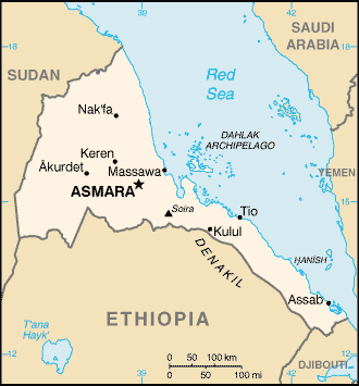
 Eritrea
África
Dive Eritrea!
Ubicación: Eastern Africa, bordering the Red Sea, between Djibouti and Sudan
Coordenadas geográficas: 15° 0' N, 39° 0' E
Km de línea costera: 2,234 km (mainland on Red Sea 1,151 km, islands in Red Sea 1,083 km) km
Clima: hot, dry desert strip along Red Sea coast; cooler and wetter in the central highlands (up to 61 cm of rainfall annually, heaviest June to September); semiarid in western hills and lowlands
Terreno: dominated by extension of Ethiopian north-south trending highlands, descending on the east to a coastal desert plain, on the northwest to hilly terrain and on the southwest to flat-to-rolling plains
Cumbres: lowest point: near Kulul within the Denakil depression -75 m
highest point: Soira 3,018 m
Riesgos naturales: frequent droughts; locust swarms
Moneda: nakfa (ERN)
Población: 4,786,994 (July 2006 est.)
Lenguas: Afar, Arabic, Tigre and Kunama, Tigrinya, other Cushitic languages
Capital: Asmara
División administrativa: 6 regions (zobatat, singular - zoba); Anseba, Debub (Southern), Debubawi K'eyih Bahri (Southern Red Sea), Gash Barka, Ma'akel (Central), Semenawi Keyih Bahri (Northern Red Sea)
Más detalles
| Jan | Feb | Mar | Apr | May | Jun | Jul | Aug | Sep | Oct | Nov | Dec | |
|---|---|---|---|---|---|---|---|---|---|---|---|---|
| Climate | ||||||||||||
| Air temp. | ||||||||||||
| Water temp. | ||||||||||||
| Equipment | Não sei | Não sei | Não sei | Não sei | Não sei | Não sei | Não sei | Não sei | Não sei | Não sei | Não sei | Não sei |
| Best season | ||||||||||||
Mapa adicional
¿Quiere añadir más informacion sobre Eritrea? Háganos saber...
¡Este es un mapa interactivo! Use los controles para recorrerlo y hacer zoom.
- Favoritos
-
Sus listas de sitios de buceo favoritos
Sitios de buceo
| Sitios de buceo (5) | Calidad | Profundidad media | Profundidad máxima | Experiencia | Tipo de buceo | ||
|---|---|---|---|---|---|---|---|
| Difnein | - / - | 49.2 ft | 59.1 ft | Para todos niveles | 
|
||
| Dissei | - / - | 49.2 ft | 65.6 ft | CMAS * / OW |
|
||
| Dry dock | - / - | 45.9 ft | 72.2 ft | CMAS * / OW | 
|
||
| Norah | - / - | 6.6 ft | 9.8 ft | Para todos niveles | 
|
||
| Two Fathom Bank | - / - | 65.6 ft | 114.8 ft | CMAS ** / AOW |
|
 Últimos logs de buceo
Comentarios
Sea el(la) primero(a) a hacer un comentario sobre este país
Errores, opiniones.
Si quiere añadir nueva información o si ha encontrado errores en esta país, Envíe sus observaciones