English (Traducir este texto en Español): The Poor Knights Islands are a group of uninhabited islands off the east coast of the Northland Region of the North Island of New Zealand. They are located 50 kilometres to the northeast of Whangarei, and lie 22 kilometres offshore half way between Bream Head and Cape Brett.
The chain consists of two large islands (Aorangi and Tawhiti Rahi) with a group of smaller islets between the two, the largest of which is called Motu Kapiti. The name Tawhiti Rahi is also used as a name for the entire chain by Māori. The islands are the eroded remnants of a 4 million year old rhyolitic volcano. The total area of the chain is 24 km².
The islands are protected as a nature reserve and a permit is required to land or tie boats up. Permits are usually granted only for scientific research.
The waters for 800 metres around the islands are a marine reserve in which it is prohibited to disturb marine life or remove rocks or shells. No commercial fishing is permitted within one nautical mile (1,852 metres) and long lining is the only commercial fishing permitted between one and three nautical miles. The islands are a popular diving location due to the variety of marine fauna found there, and are popular also for their intriguing landforms, which include natural arches and caves.
The origin of the name is said to derive from the islands' apparent resemblance to Poor Knight's Pudding, a bread-based dish popular at the time of discovery by Europeans. Source: Wikipedia.org
Distance from Aukland: Day Trip
Viz: 15-30 m
Water temp: 23°C in summer, 14°C in winter
Number of dive sites: Approx 50!
The Poor Knights Islands are a group of uninhabited islands off the east coast of the Northland Region of the North Island of New Zealand. They are located 50 kilometres to the northeast of Whangarei, and lie 22 kilometres offshore half way between Bream Head and Cape Brett.
The chain consists of two large islands (Aorangi and Tawhiti Rahi) with a group of smaller islets between the two, the largest of which is called Motu Kapiti. The name Tawhiti Rahi is also used as a name for the entire chain by Māori. The islands are the eroded remnants of a 4 million year old rhyolitic volcano. The total area of the chain is 24 km².
The islands are protected as a nature reserve and a permit is required to land or tie boats up. Permits are usually granted only for scientific research.
The waters for 800 metres around the islands are a marine reserve in which it is prohibited to disturb marine life or remove rocks or shells. No commercial fishing is permitted within one nautical mile (1,852 metres) and long lining is the only commercial fishing permitted between one and three nautical miles. The islands are a popular diving location due to the variety of marine fauna found there, and are popular also for their intriguing landforms, which include natural arches and caves.
The origin of the name is said to derive from the islands' apparent resemblance to Poor Knight's Pudding, a bread-based dish popular at the time of discovery by Europeans. Source: Wikipedia.org
Distance from Aukland: Day Trip
Viz: 15-30 m
Water temp: 23°C in summer, 14°C in winter
Number of dive sites: Approx 50!
English (Traducir este texto en Español): The Poor Knights Islands are a group of uninhabited islands off the east coast of the Northland Region of the North Island of New Zealand. They are located 50 kilometres to the northeast of Whangarei, and lie 22 kilometres offshore half way between Bream Head and Cape Brett.
The chain consists of two large islands (Aorangi and Tawhiti Rahi) with a group of smaller islets between the two, the largest of which is called Motu Kapiti. The name Tawhiti Rahi is also used as a name for the entire chain by Māori. The islands are the eroded remnants of a 4 million year old rhyolitic volcano. The total area of the chain is 24 km².
The islands are protected as a nature reserve and a permit is required to land or tie boats up. Permits are usually granted only for scientific research.
The waters for 800 metres around the islands are a marine reserve in which it is prohibited to disturb marine life or remove rocks or shells. No commercial fishing is permitted within one nautical mile (1,852 metres) and long lining is the only commercial fishing permitted between one and three nautical miles. The islands are a popular diving location due to the variety of marine fauna found there, and are popular also for their intriguing landforms, which include natural arches and caves.
The origin of the name is said to derive from the islands' apparent resemblance to Poor Knight's Pudding, a bread-based dish popular at the time of discovery by Europeans. Source: Wikipedia.org
Distance from Aukland: Day Trip
Viz: 15-30 m
Water temp: 23°C in summer, 14°C in winter
Number of dive sites: Approx 50!
 Poor Knights Islands


 Fotos
Fotos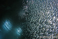


Por Anonymous , 06-02-2009
The diving at the Poor Knights is excellent - The diving at the Poor Knights is excellent. For many years they have been recognized as New Zealand’s top scuba diving location, and were considered by Jacques Cousteau to be one of the top scuba dive sites of the world. There is greater diversity of underwater habitats and wildlife than elsewhere around New Zealand due to a combination of adjacent deep water, near vertical underwater cliffs, shallow sheltered bays, arches, caves and tunnels bathed by the warm East Auckland current. This has introduced subtropical species such as Spotted Black, Toadstool and Gold Ribbon groupers; Lord Howe Island Coral Fish and Banded Coral Shrimp, all of which have become established. Rare arrivals have included Lionfish, Trumpet Fish, Long-nosed Butterfly Fish and occasional Hawksbill Turtles. Seen on most dives are many Moray eels (six species occur), Rays (four species) and schools of many other species including Kingfish up to
40kg.scorpian fish The caves and arches are home to demoiselles and both pink and blue maomao. On the walls there are colorful sponges, anemones, gorgonian soft corals, bryozoans and tunicates; all of these, together with beautiful nudibranchs make these NZ islands an underwater photographers paradise.