¿Ha perdido la contraseña?
¿Nuevo usuario? Crear una cuenta
Clownfish, Philippines. Photo by Stephane Rochon.
¡Disfrute y contribuya!
| Encontrar los mejores sitios |
|
|
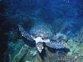
 Útila Island
Honduras, Bay Islands
English (Traducir este texto en Español): Útila (Isla de Útila) is the third largest of Honduras' Bay Islands, after Roatán and Guanaja, in a region that marks the south end of the Mesoamerican Barrier Reef System, the second-largest in the world. The eastern end of the island is capped by a thin veneer of basaltic volcanic rocks, erupted from several pyroclastic cones including 74 m (243 ft) Pumpkin Hill which forms the highest point on the island. It has been documented in history since Columbus' fourth voyage, and currently enjoys growing tourism with emphasis on recreational diving.
Más detalles
| Jan | Feb | Mar | Apr | May | Jun | Jul | Aug | Sep | Oct | Nov | Dec | |
|---|---|---|---|---|---|---|---|---|---|---|---|---|
| Climate | ||||||||||||
| Air temp. | ||||||||||||
| Water temp. | ||||||||||||
| Equipment | Nie wiem | Nie wiem | Nie wiem | Nie wiem | Nie wiem | Nie wiem | Nie wiem | Nie wiem | Nie wiem | Nie wiem | Nie wiem | Nie wiem |
| Best season | ||||||||||||
¡Este es un mapa interactivo! Use los controles para recorrerlo y hacer zoom.
- Favoritos
-
Sus listas de sitios de buceo favoritos
Sitios de buceo
| Sitios de buceo (21) | Calidad | Profundidad media | Profundidad máxima | Experiencia | Tipo de buceo | ||
|---|---|---|---|---|---|---|---|
| Airport Caves | - / - | 10 m | 18 m | Para todos niveles | 
|
||
| Aquarium | - / - | 15.2 m | 18.3 m | CMAS * / OW |
|
||
| Black Corral Wall | - / - | 4.6 m | 39.6 m | Para todos niveles | 

|
||
| Black Hills | 3 / - | 12 m | 30 m | Para todos niveles | 

|
||
| Blackish Point | - / - | 15 m | 26 m | Para todos niveles |
|
||
| CJ's Dropoff | - / - | 15.2 m | 36.6 m | Para todos niveles |
|
||
| Duppy Waters | 1 / - | 15 m | 30 m | Para todos niveles |
|
||
| Eagle Ray Alley | - / - | 15 m | 24 m | Para todos niveles |
|
||
| Great Wall | - / - | 20 m | 29 m | CMAS * / OW |
|
||
| Halliburton | 2 / - | 27 m | 31 m | Para todos niveles | 
|
||
| Jack's Bight | - / - | 6.1 m | 19.8 m | CMAS * / OW |
|
||
| Little Bight | - / - | 7 m | 30 m | Para todos niveles |
|
||
| moon hole | - / - | 4.6 m | 24.4 m | Para todos niveles |
|
||
| Old House | 2 / - | 15 m | 40 m | Para todos niveles |
|
||
| Raggedy Cay | - / - | 15 m | 30 m | Para todos niveles |
|
||
| Ships Stern | - / - | 15 m | 25 m | Para todos niveles | 
|
||
| Silver Garden | - / - | 9.1 m | 36.6 m | Para todos niveles |
|
||
| Sting Ray Point | - / - | 15.2 m | 23.2 m | Para todos niveles | 
|
||
| Ted's Point West | - / - | 15.2 m | 18 m | Para todos niveles |

|
||
| The Maze | - / - | 15 m | 40 m | CMAS * / OW |
|
||
| Utila Open Water | 1 / - | 3 m | 15 m | Para todos niveles | 
|

 Comentarios
Sea el(la) primero(a) a hacer un comentario sobre este país
Errores, opiniones.
Puede editar esta página para corregir los errores y añadir nueva información. Si tiene otros comentarios sobre esta página, Envíe sus observaciones