¡Este es un mapa interactivo! Use los controles para recorrerlo y hacer zoom.
Acceso
|
English (Traducir este texto en Español): Saranda bay
English (Traducir este texto en Español): Saranda bay
Saranda bay
English (Traducir este texto en Español): Saranda bay
English (Traducir este texto en Español): Saranda bay
English (Traducir este texto en Español): Saranda bay
English (Traducir este texto en Español): Saranda bay
English (Traducir este texto en Español): Saranda bay
English (Traducir este texto en Español): Saranda bay
¿Como?
Distancia
¿Fácil de encontrar?
|
|
Características del sitio de buceo
Profundidad media 15 m / 49.2 ft
Profundidad máxima 30 m / 98.4 ft
Corriente
Visibilidad
Calidad
Calidad del sitio
Experiencia
Bio interés
Más detalles
Multitud entre semana
Multitud en fin/semana
Tipo de buceo
Actividades del sitio de buceo
Peligros
Información adicional
English (Traducir este texto en Español): Inside the Bay of Saranda there lies an Italian cargoship. It was sunk during the II World War by German Bombers on their way back from an attack on the Balkans. Traces of the bombs can still be seen on the ships sides! The vessel lies on its port side on the sandy bed at a maximum depth of 18m just 300m away from the shore. At the shallowest point the ship is just 3m form the surface and is marked with a bouy. The ship is roughly 115m long. It is marked above water by a Cardinal bouy signalling danger. Visibility underwater is good about 20m.
English (Traducir este texto en Español): Inside the Bay of Saranda there lies an Italian cargoship. It was sunk during the II World War by German Bombers on their way back from an attack on the Balkans. Traces of the bombs can still be seen on the ships sides! The vessel lies on its port side on the sandy bed at a maximum depth of 18m just 300m away from the shore. At the shallowest point the ship is just 3m form the surface and is marked with a bouy. The ship is roughly 115m long. It is marked above water by a Cardinal bouy signalling danger. Visibility underwater is good about 20m.
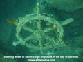
Inside the Bay of Saranda there lies an Italian cargoship. It was sunk during the II World War by German Bombers on their way back from an attack on the Balkans. Traces of the bombs can still be seen on the ships sides! The vessel lies on its port side on the sandy bed at a maximum depth of 18m just 300m away from the shore. At the shallowest point the ship is just 3m form the surface and is marked with a bouy. The ship is roughly 115m long. It is marked above water by a Cardinal bouy signalling danger. Visibility underwater is good about 20m.
English (Traducir este texto en Español): Inside the Bay of Saranda there lies an Italian cargoship. It was sunk during the II World War by German Bombers on their way back from an attack on the Balkans. Traces of the bombs can still be seen on the ships sides! The vessel lies on its port side on the sandy bed at a maximum depth of 18m just 300m away from the shore. At the shallowest point the ship is just 3m form the surface and is marked with a bouy. The ship is roughly 115m long. It is marked above water by a Cardinal bouy signalling danger. Visibility underwater is good about 20m.
English (Traducir este texto en Español): Inside the Bay of Saranda there lies an Italian cargoship. It was sunk during the II World War by German Bombers on their way back from an attack on the Balkans. Traces of the bombs can still be seen on the ships sides! The vessel lies on its port side on the sandy bed at a maximum depth of 18m just 300m away from the shore. At the shallowest point the ship is just 3m form the surface and is marked with a bouy. The ship is roughly 115m long. It is marked above water by a Cardinal bouy signalling danger. Visibility underwater is good about 20m.
English (Traducir este texto en Español): Inside the Bay of Saranda there lies an Italian cargoship. It was sunk during the II World War by German Bombers on their way back from an attack on the Balkans. Traces of the bombs can still be seen on the ships sides! The vessel lies on its port side on the sandy bed at a maximum depth of 18m just 300m away from the shore. At the shallowest point the ship is just 3m form the surface and is marked with a bouy. The ship is roughly 115m long. It is marked above water by a Cardinal bouy signalling danger. Visibility underwater is good about 20m.
English (Traducir este texto en Español): Inside the Bay of Saranda there lies an Italian cargoship. It was sunk during the II World War by German Bombers on their way back from an attack on the Balkans. Traces of the bombs can still be seen on the ships sides! The vessel lies on its port side on the sandy bed at a maximum depth of 18m just 300m away from the shore. At the shallowest point the ship is just 3m form the surface and is marked with a bouy. The ship is roughly 115m long. It is marked above water by a Cardinal bouy signalling danger. Visibility underwater is good about 20m.
English (Traducir este texto en Español): Inside the Bay of Saranda there lies an Italian cargoship. It was sunk during the II World War by German Bombers on their way back from an attack on the Balkans. Traces of the bombs can still be seen on the ships sides! The vessel lies on its port side on the sandy bed at a maximum depth of 18m just 300m away from the shore. At the shallowest point the ship is just 3m form the surface and is marked with a bouy. The ship is roughly 115m long. It is marked above water by a Cardinal bouy signalling danger. Visibility underwater is good about 20m.
English (Traducir este texto en Español): Inside the Bay of Saranda there lies an Italian cargoship. It was sunk during the II World War by German Bombers on their way back from an attack on the Balkans. Traces of the bombs can still be seen on the ships sides! The vessel lies on its port side on the sandy bed at a maximum depth of 18m just 300m away from the shore. At the shallowest point the ship is just 3m form the surface and is marked with a bouy. The ship is roughly 115m long. It is marked above water by a Cardinal bouy signalling danger. Visibility underwater is good about 20m.
 Comentarios
Por favor regístrese para usar esta herramienta.
¿Aún no está registrado? Regístrese primero; ¡es gratis!
Mostrar todo (0)...
Sea el(la) primero(a) a hacer un comentario sobre este país
Errores, opiniones.
Puede editar esta página para corregir los errores y añadir nueva información. Si tiene otros comentarios sobre esta página, Envíe sus observaciones
Wannadive.net 24/24
Wannadive.net en su móvil

Boletín Todas las noticias por correo electrónico
 Italian Freighter Probitas