¡Este es un mapa interactivo! Use los controles para recorrerlo y hacer zoom.
Acceso
|
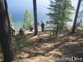
¿Como? Desde la costa
Distancia Acceso inmediato
¿Fácil de encontrar? Fácil de encontrar
|
|
Características del sitio de buceo
Profundidad media 7 m / 23 ft
Profundidad máxima 12 m / 39.4 ft
Corriente Ninguna corriente
Visibilidad Mediana ( 5 - 10 m)
Calidad
Calidad del sitio Bueno
Experiencia Para todos niveles
Bio interés Interesante
Más detalles
Multitud entre semana
Multitud en fin/semana
Tipo de buceo
- Agua dulce
Actividades del sitio de buceo
- Biologia marina
- Buceo infantil
- Buceo nocturno
- Bautismo
- Entrenamiento de buceo
- Snorkel / Buceo libre
- Orientación
- Fotografía
Peligros
Información adicional
English (Traducir este texto en Español): From the entrance zone, following 210 the stone formation can be reached after about 100m on 7m deep. Till the stones max depth is about 12m. On the left side of the entrance after few meters on max dept 2m there is a underwater grass field that usually have pentry of fishes. Going straight towards middle of the lake, the depth can reach over 20m but there is only mud, cold and darkness.
English (Traducir este texto en Español): From the entrance zone, following 210 the stone formation can be reached after about 100m on 7m deep. Till the stones max depth is about 12m. On the left side of the entrance after few meters on max dept 2m there is a underwater grass field that usually have pentry of fishes. Going straight towards middle of the lake, the depth can reach over 20m but there is only mud, cold and darkness.
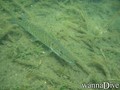
From the entrance zone, following 210 the stone formation can be reached after about 100m on 7m deep. Till the stones max depth is about 12m. On the left side of the entrance after few meters on max dept 2m there is a underwater grass field that usually have pentry of fishes. Going straight towards middle of the lake, the depth can reach over 20m but there is only mud, cold and darkness.
English (Traducir este texto en Español): From the entrance zone, following 210 the stone formation can be reached after about 100m on 7m deep. Till the stones max depth is about 12m. On the left side of the entrance after few meters on max dept 2m there is a underwater grass field that usually have pentry of fishes. Going straight towards middle of the lake, the depth can reach over 20m but there is only mud, cold and darkness.
English (Traducir este texto en Español): From the entrance zone, following 210 the stone formation can be reached after about 100m on 7m deep. Till the stones max depth is about 12m. On the left side of the entrance after few meters on max dept 2m there is a underwater grass field that usually have pentry of fishes. Going straight towards middle of the lake, the depth can reach over 20m but there is only mud, cold and darkness.
English (Traducir este texto en Español): From the entrance zone, following 210 the stone formation can be reached after about 100m on 7m deep. Till the stones max depth is about 12m. On the left side of the entrance after few meters on max dept 2m there is a underwater grass field that usually have pentry of fishes. Going straight towards middle of the lake, the depth can reach over 20m but there is only mud, cold and darkness.
English (Traducir este texto en Español): From the entrance zone, following 210 the stone formation can be reached after about 100m on 7m deep. Till the stones max depth is about 12m. On the left side of the entrance after few meters on max dept 2m there is a underwater grass field that usually have pentry of fishes. Going straight towards middle of the lake, the depth can reach over 20m but there is only mud, cold and darkness.
English (Traducir este texto en Español): From the entrance zone, following 210 the stone formation can be reached after about 100m on 7m deep. Till the stones max depth is about 12m. On the left side of the entrance after few meters on max dept 2m there is a underwater grass field that usually have pentry of fishes. Going straight towards middle of the lake, the depth can reach over 20m but there is only mud, cold and darkness.
English (Traducir este texto en Español): From the entrance zone, following 210 the stone formation can be reached after about 100m on 7m deep. Till the stones max depth is about 12m. On the left side of the entrance after few meters on max dept 2m there is a underwater grass field that usually have pentry of fishes. Going straight towards middle of the lake, the depth can reach over 20m but there is only mud, cold and darkness.
 Comentarios
Por favor regístrese para usar esta herramienta.
¿Aún no está registrado? Regístrese primero; ¡es gratis!
Mostrar todo (0)...
Sea el(la) primero(a) a hacer un comentario sobre este país
Errores, opiniones.
Puede editar esta página para corregir los errores y añadir nueva información. Si tiene otros comentarios sobre esta página, Envíe sus observaciones
Wannadive.net 24/24
Wannadive.net en su móvil

Boletín Todas las noticias por correo electrónico
 Iso-Melkutin