¡Este es un mapa interactivo! Use los controles para recorrerlo y hacer zoom.
Acceso
|
English (Traducir este texto en Español): Northeast of Halifax along the Marine Drive Hwy #7 is the community of Sheet Harbour. The habour splits into the main channel and an eat branch called East River. The tramp freighter ARCTIC TRADER caught fire twice at dockside on the large wharf. On the second time, she was cut free and ended up anchored out in front of the floating docks of a small yacht club, just south of the main wharf. Torpedo Rays Dive Shop has a good online write up for it, which led us to explore the spot. Take the righthand paved road shortly before crossing the large, green, steel East River Bridge. There is parking out of the way near the wharf and above the yacht club. Don't block the boat ramp.
English (Traducir este texto en Español): Northeast of Halifax along the Marine Drive Hwy #7 is the community of Sheet Harbour. The habour splits into the main channel and an eat branch called East River. The tramp freighter ARCTIC TRADER caught fire twice at dockside on the large wharf. On the second time, she was cut free and ended up anchored out in front of the floating docks of a small yacht club, just south of the main wharf. Torpedo Rays Dive Shop has a good online write up for it, which led us to explore the spot. Take the righthand paved road shortly before crossing the large, green, steel East River Bridge. There is parking out of the way near the wharf and above the yacht club. Don't block the boat ramp.
Northeast of Halifax along the Marine Drive Hwy #7 is the community of Sheet Harbour. The habour splits into the main channel and an eat branch called East River. The tramp freighter ARCTIC TRADER caught fire twice at dockside on the large wharf. On the second time, she was cut free and ended up anchored out in front of the floating docks of a small yacht club, just south of the main wharf. Torpedo Rays Dive Shop has a good online write up for it, which led us to explore the spot. Take the righthand paved road shortly before crossing the large, green, steel East River Bridge. There is parking out of the way near the wharf and above the yacht club. Don't block the boat ramp.
English (Traducir este texto en Español): Northeast of Halifax along the Marine Drive Hwy #7 is the community of Sheet Harbour. The habour splits into the main channel and an eat branch called East River. The tramp freighter ARCTIC TRADER caught fire twice at dockside on the large wharf. On the second time, she was cut free and ended up anchored out in front of the floating docks of a small yacht club, just south of the main wharf. Torpedo Rays Dive Shop has a good online write up for it, which led us to explore the spot. Take the righthand paved road shortly before crossing the large, green, steel East River Bridge. There is parking out of the way near the wharf and above the yacht club. Don't block the boat ramp.
English (Traducir este texto en Español): Northeast of Halifax along the Marine Drive Hwy #7 is the community of Sheet Harbour. The habour splits into the main channel and an eat branch called East River. The tramp freighter ARCTIC TRADER caught fire twice at dockside on the large wharf. On the second time, she was cut free and ended up anchored out in front of the floating docks of a small yacht club, just south of the main wharf. Torpedo Rays Dive Shop has a good online write up for it, which led us to explore the spot. Take the righthand paved road shortly before crossing the large, green, steel East River Bridge. There is parking out of the way near the wharf and above the yacht club. Don't block the boat ramp.
English (Traducir este texto en Español): Northeast of Halifax along the Marine Drive Hwy #7 is the community of Sheet Harbour. The habour splits into the main channel and an eat branch called East River. The tramp freighter ARCTIC TRADER caught fire twice at dockside on the large wharf. On the second time, she was cut free and ended up anchored out in front of the floating docks of a small yacht club, just south of the main wharf. Torpedo Rays Dive Shop has a good online write up for it, which led us to explore the spot. Take the righthand paved road shortly before crossing the large, green, steel East River Bridge. There is parking out of the way near the wharf and above the yacht club. Don't block the boat ramp.
English (Traducir este texto en Español): Northeast of Halifax along the Marine Drive Hwy #7 is the community of Sheet Harbour. The habour splits into the main channel and an eat branch called East River. The tramp freighter ARCTIC TRADER caught fire twice at dockside on the large wharf. On the second time, she was cut free and ended up anchored out in front of the floating docks of a small yacht club, just south of the main wharf. Torpedo Rays Dive Shop has a good online write up for it, which led us to explore the spot. Take the righthand paved road shortly before crossing the large, green, steel East River Bridge. There is parking out of the way near the wharf and above the yacht club. Don't block the boat ramp.
English (Traducir este texto en Español): Northeast of Halifax along the Marine Drive Hwy #7 is the community of Sheet Harbour. The habour splits into the main channel and an eat branch called East River. The tramp freighter ARCTIC TRADER caught fire twice at dockside on the large wharf. On the second time, she was cut free and ended up anchored out in front of the floating docks of a small yacht club, just south of the main wharf. Torpedo Rays Dive Shop has a good online write up for it, which led us to explore the spot. Take the righthand paved road shortly before crossing the large, green, steel East River Bridge. There is parking out of the way near the wharf and above the yacht club. Don't block the boat ramp.
English (Traducir este texto en Español): Northeast of Halifax along the Marine Drive Hwy #7 is the community of Sheet Harbour. The habour splits into the main channel and an eat branch called East River. The tramp freighter ARCTIC TRADER caught fire twice at dockside on the large wharf. On the second time, she was cut free and ended up anchored out in front of the floating docks of a small yacht club, just south of the main wharf. Torpedo Rays Dive Shop has a good online write up for it, which led us to explore the spot. Take the righthand paved road shortly before crossing the large, green, steel East River Bridge. There is parking out of the way near the wharf and above the yacht club. Don't block the boat ramp.
¿Como? Desde la costa
Distancia Acceso inmediato
¿Fácil de encontrar? Fácil de encontrar
|
|
Características del sitio de buceo
Profundidad media 4.6 m / 15.1 ft
Profundidad máxima 10.7 m / 35.1 ft
Corriente Mediana ( 1-2 nudos)
Visibilidad Baja ( < 5 m)
Calidad
Calidad del sitio Bueno
Experiencia CMAS ** / AOW
Bio interés Interesante
Más detalles
Multitud entre semana
Multitud en fin/semana
Tipo de buceo
- Agua dulce
- Pecios
Actividades del sitio de buceo
- Biologia marina
- Entrenamiento de buceo
- Fotografía
Peligros
- Corriente
- Tráfico de barcos
- Redes
Información adicional
English (Traducir este texto en Español): The top 2-3m is freshwater that has tannins in it, which makes it brown and dark. Below that is saltwater which increases with the tide cycle with a range of 2m. After diving the spot at low tide, I'd recommend just before high tide when more clearer saltwater covers the ship.
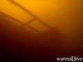
Going straight out from the boat ramp or the floating dock, you swim right into the bottom of the hull. the ship is bow to the left, down river, and is lying on its port side faced away from the shore. A nice route is up on the flank of the ship away from the very slity bottom; go right on top of the hull to the bow; then hop inside to go along the upper portion of the deck near the starboard railings. This way you can drop down onto the superstructure as you see it below you. On the ship there is little current, but up in the freshwater or on the surface, it can run 0.5 to 1.5 knots. Only properly trained and equipped divers should penetrate - all others stay outside and shinelights in the hatchways and windows. There are some lines, collapsing structures, and some netting so care is required moving along the ship. Railing in the saltwater are cloaked in sea anemones. Main lights, marker lghts and backup lights are recommended. Good buddy team work is essential to a fun safe dive.
We only dive this site outside of summer to reduce pleasure boat traffic - from October to April or May, divers will almost have the site to themselves.
English (Traducir este texto en Español): The top 2-3m is freshwater that has tannins in it, which makes it brown and dark. Below that is saltwater which increases with the tide cycle with a range of 2m. After diving the spot at low tide, I'd recommend just before high tide when more clearer saltwater covers the ship.
Going straight out from the boat ramp or the floating dock, you swim right into the bottom of the hull. the ship is bow to the left, down river, and is lying on its port side faced away from the shore. A nice route is up on the flank of the ship away from the very slity bottom; go right on top of the hull to the bow; then hop inside to go along the upper portion of the deck near the starboard railings. This way you can drop down onto the superstructure as you see it below you. On the ship there is little current, but up in the freshwater or on the surface, it can run 0.5 to 1.5 knots. Only properly trained and equipped divers should penetrate - all others stay outside and shinelights in the hatchways and windows. There are some lines, collapsing structures, and some netting so care is required moving along the ship. Railing in the saltwater are cloaked in sea anemones. Main lights, marker lghts and backup lights are recommended. Good buddy team work is essential to a fun safe dive.
We only dive this site outside of summer to reduce pleasure boat traffic - from October to April or May, divers will almost have the site to themselves.
The top 2-3m is freshwater that has tannins in it, which makes it brown and dark. Below that is saltwater which increases with the tide cycle with a range of 2m. After diving the spot at low tide, I'd recommend just before high tide when more clearer saltwater covers the ship.
Going straight out from the boat ramp or the floating dock, you swim right into the bottom of the hull. the ship is bow to the left, down river, and is lying on its port side faced away from the shore. A nice route is up on the flank of the ship away from the very slity bottom; go right on top of the hull to the bow; then hop inside to go along the upper portion of the deck near the starboard railings. This way you can drop down onto the superstructure as you see it below you. On the ship there is little current, but up in the freshwater or on the surface, it can run 0.5 to 1.5 knots. Only properly trained and equipped divers should penetrate - all others stay outside and shinelights in the hatchways and windows. There are some lines, collapsing structures, and some netting so care is required moving along the ship. Railing in the saltwater are cloaked in sea anemones. Main lights, marker lghts and backup lights are recommended. Good buddy team work is essential to a fun safe dive.
We only dive this site outside of summer to reduce pleasure boat traffic - from October to April or May, divers will almost have the site to themselves.
English (Traducir este texto en Español): The top 2-3m is freshwater that has tannins in it, which makes it brown and dark. Below that is saltwater which increases with the tide cycle with a range of 2m. After diving the spot at low tide, I'd recommend just before high tide when more clearer saltwater covers the ship.
Going straight out from the boat ramp or the floating dock, you swim right into the bottom of the hull. the ship is bow to the left, down river, and is lying on its port side faced away from the shore. A nice route is up on the flank of the ship away from the very slity bottom; go right on top of the hull to the bow; then hop inside to go along the upper portion of the deck near the starboard railings. This way you can drop down onto the superstructure as you see it below you. On the ship there is little current, but up in the freshwater or on the surface, it can run 0.5 to 1.5 knots. Only properly trained and equipped divers should penetrate - all others stay outside and shinelights in the hatchways and windows. There are some lines, collapsing structures, and some netting so care is required moving along the ship. Railing in the saltwater are cloaked in sea anemones. Main lights, marker lghts and backup lights are recommended. Good buddy team work is essential to a fun safe dive.
We only dive this site outside of summer to reduce pleasure boat traffic - from October to April or May, divers will almost have the site to themselves.
 Comentarios
Por favor regístrese para usar esta herramienta.
¿Aún no está registrado? Regístrese primero; ¡es gratis!
Mostrar todo (0)...
Sea el(la) primero(a) a hacer un comentario sobre este país
Errores, opiniones.
Puede editar esta página para corregir los errores y añadir nueva información. Si tiene otros comentarios sobre esta página, Envíe sus observaciones
 Arctic Trader shipwreck