¡Este es un mapa interactivo! Use los controles para recorrerlo y hacer zoom.
Acceso
|
English (Traducir este texto en Español): Jeffreys Ledge is a large glacially-created feature, stretching 33 miles from offshore of Rockport, MA to Cape Elizabeth, ME. Dive charters departing from Gloucester run special trips upon request.
English (Traducir este texto en Español): Jeffreys Ledge is a large glacially-created feature, stretching 33 miles from offshore of Rockport, MA to Cape Elizabeth, ME. Dive charters departing from Gloucester run special trips upon request.
Jeffreys Ledge is a large glacially-created feature, stretching 33 miles from offshore of Rockport, MA to Cape Elizabeth, ME. Dive charters departing from Gloucester run special trips upon request.
English (Traducir este texto en Español): Jeffreys Ledge is a large glacially-created feature, stretching 33 miles from offshore of Rockport, MA to Cape Elizabeth, ME. Dive charters departing from Gloucester run special trips upon request.
English (Traducir este texto en Español): Jeffreys Ledge is a large glacially-created feature, stretching 33 miles from offshore of Rockport, MA to Cape Elizabeth, ME. Dive charters departing from Gloucester run special trips upon request.
English (Traducir este texto en Español): Jeffreys Ledge is a large glacially-created feature, stretching 33 miles from offshore of Rockport, MA to Cape Elizabeth, ME. Dive charters departing from Gloucester run special trips upon request.
English (Traducir este texto en Español): Jeffreys Ledge is a large glacially-created feature, stretching 33 miles from offshore of Rockport, MA to Cape Elizabeth, ME. Dive charters departing from Gloucester run special trips upon request.
English (Traducir este texto en Español): Jeffreys Ledge is a large glacially-created feature, stretching 33 miles from offshore of Rockport, MA to Cape Elizabeth, ME. Dive charters departing from Gloucester run special trips upon request.
English (Traducir este texto en Español): Jeffreys Ledge is a large glacially-created feature, stretching 33 miles from offshore of Rockport, MA to Cape Elizabeth, ME. Dive charters departing from Gloucester run special trips upon request.
¿Como? En barco
Distancia Largo trayecto de barco (> 30min)
¿Fácil de encontrar? Difícil de encontrar
|
|
Características del sitio de buceo
Profundidad media 36.6 m / 120.1 ft
Profundidad máxima 36.6 m / 120.1 ft
Corriente Mediana ( 1-2 nudos)
Visibilidad Excelente ( > 30 m)
Calidad
Calidad del sitio Estupendo
Experiencia CMAS ** / AOW
Bio interés Excepcional
Más detalles
Multitud entre semana
Multitud en fin/semana
Tipo de buceo
- Buceo con corrientes
- Grandes peces
Actividades del sitio de buceo
- Biologia marina
Peligros
- Profundidad
- Corriente
- Redes
Información adicional
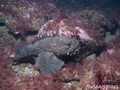
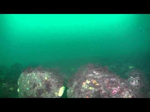
English (Traducir este texto en Español): On the northern edge of NOAA's Stellwagen Bank National Marine Sanctuary, rocky ridges on the southern edge of Jeffreys Ledge rise to within 115 feet of the surface. The shallowest portion of the ledge is comprised of piled cobble and boulders. Anemones, stalked tunicates, and coralline algae reside on the rocks making for a colorful landscape when illuminated with a dive light. The ledge’s piled boulders create a complex structure with many crevices for marine fishes like cusk and wolffish.
For more information visit: http://stellwagen.noaa.gov/visit/diving/diving.html
On the northern edge of NOAA's Stellwagen Bank National Marine Sanctuary, rocky ridges on the southern edge of Jeffreys Ledge rise to within 115 feet of the surface. The shallowest portion of the ledge is comprised of piled cobble and boulders. Anemones, stalked tunicates, and coralline algae reside on the rocks making for a colorful landscape when illuminated with a dive light. The ledge’s piled boulders create a complex structure with many crevices for marine fishes like cusk and wolffish.
For more information visit: http://stellwagen.noaa.gov/visit/diving/diving.html
English (Traducir este texto en Español): On the northern edge of NOAA's Stellwagen Bank National Marine Sanctuary, rocky ridges on the southern edge of Jeffreys Ledge rise to within 115 feet of the surface. The shallowest portion of the ledge is comprised of piled cobble and boulders. Anemones, stalked tunicates, and coralline algae reside on the rocks making for a colorful landscape when illuminated with a dive light. The ledge’s piled boulders create a complex structure with many crevices for marine fishes like cusk and wolffish.
For more information visit: http://stellwagen.noaa.gov/visit/diving/diving.html
 Comentarios
Por favor regístrese para usar esta herramienta.
¿Aún no está registrado? Regístrese primero; ¡es gratis!
Mostrar todo (0)...
Sea el(la) primero(a) a hacer un comentario sobre este país
Errores, opiniones.
Puede editar esta página para corregir los errores y añadir nueva información. Si tiene otros comentarios sobre esta página, Envíe sus observaciones
Wannadive.net 24/24
Wannadive.net en su móvil

Boletín Todas las noticias por correo electrónico
 Jeffreys Ledge